タミル・ナードゥ州の地区一覧:行政区画・地図と主要都市ガイド
タミル・ナードゥ州の全地区を地図で解説。行政区画、主要都市、観光・交通情報を一目で把握できる完全ガイド。
- 中央
- カルル(Karur / カールル)— 繊維・製陶で知られる内陸の工業都市。行政的には中央部に位置し、タルーク(taluk)を管轄します。
- ティルチラッパラッリ(Tiruchirappalli / トリチー)— 歴史ある都市で空軍基地や教育機関が集中。中心都市として交通の要所です。
- 西
- Coimbatore(コインバトール / Coimbatore)— 工業と繊維の中心地。丘陵地帯に近く、経済的にも州内で重要な役割を果たします。
- クリシュナギリ(Krishnagiri / クリシュナギリ)— 農産物(特に果物)と工業が混在する地域。西部の入口に位置します。
- ナマッカル(Namakkal / ナマッカル)— 住宅車両・運送業が発展している内陸地区。岩山や古い寺院が点在します。
- セーラム(Salem / セーラム)— 繊維・鉄鋼関連産業が盛んな都市。西部の工業地帯の中心です。
- ティルプルプル(Tiruppur / ティルプール)— ニット製品の大量生産で知られる輸出拠点。西部経済の重要エリアです。
- 南
- 挖色(※原文の表記を保持) — 南部の内陸または沿岸地域に位置する地区。主要都市や交通網については下記の「主要都市ガイド」を参照してください。
- 蟹工泊(※原文の表記を保持) — 南部沿岸に近い地区の可能性があり、漁業や海産業が関係する地域です。
- ラマナタプラム(Ramanathapuram / ラーマナタプラム)— 歴史的な港町や漁業で知られる南東沿岸の地区。観光地も点在します。
- Sivagangai(Sivagangai / シヴァガンガイ)— 農業を基盤とする内陸地区。歴史的・文化的な遺産も多く残ります。
- Virudhunagar(Virudhunagar / ヴィルドゥナガル)— 商業と中小産業が発達した地域。南部の物流拠点の一つです。
- Tenkasi(Tenkasi / テンカシ)— 西ガーツの麓に位置する自然豊かな地域で、滝や山岳観光が魅力です。
- 北
- チェンナイ(Chennai / チェンナイ)— 州都であり政治・経済・文化の中心。港湾、IT、教育機関が集中しています。
- カッダローレ(Cuddalore / カッダローレ)— 北東沿岸の港湾・工業地域。沿岸災害の影響を受けやすい地域でもあります。
- かんちぷらーむ(Kanchipuram / カーンチープラム)— 歴史的寺院群と絹織物で有名。チェンナイ近郊の文化的拠点です。
- ティルヴァルール(Tiruvarur / ティルヴァールール)— 農業中心の平坦地に位置し、古い寺院や祭礼で知られます。
- ヴェローレ(Vellore / ヴェローレ)— 医療・教育・歴史的要素が強い都市。北部内陸のハブです。
- カラクリチ(Kallakurichi / カッラクリチ)— 近年行政区画が見直されて成立した地区で、農業と林業が中心です。
- Ranipet — 工業団地や化学工業が集積している北部の重要な産業拠点の一つです。
画像ギャラリー
6 画像


行政区画について
タミル・ナードゥ州は多数の地区(district)に分かれており、各地区はさらにタルーク(tahsil / taluk)やブロック、村(panchayat)や市(municipality)へと細分されます。地区ごとに行政本部(district headquarters)があり、地方行政・治安・開発計画を統括します。
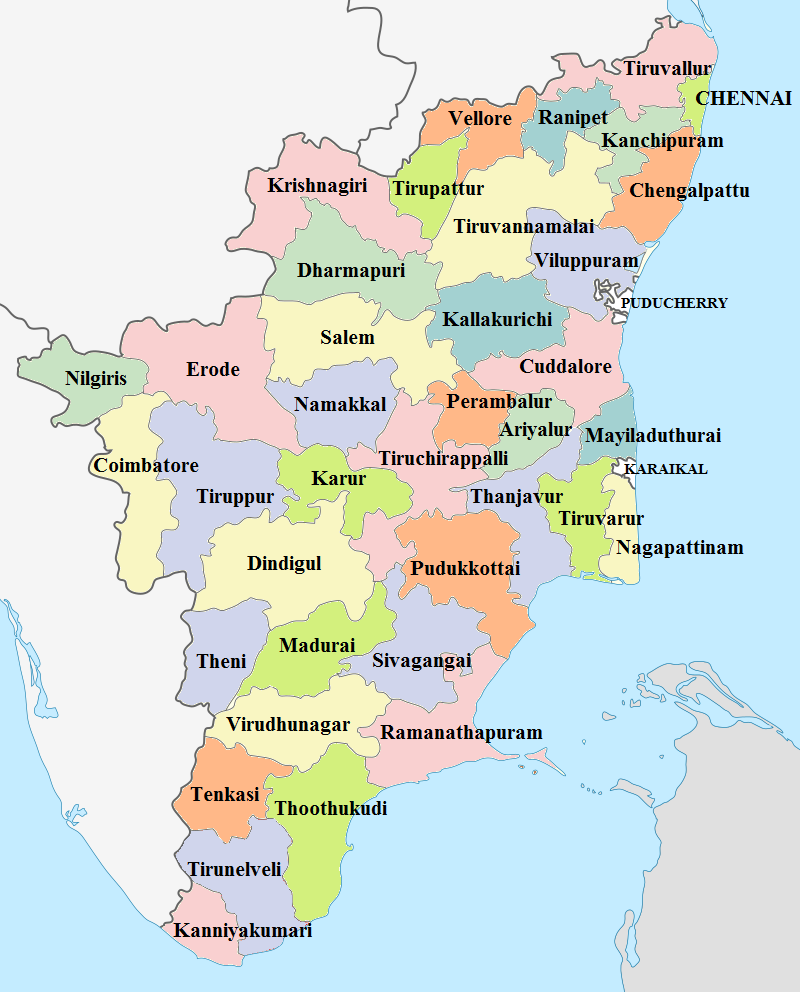
地図と主要都市ガイド
地図で地区を確認する際は、以下を目安にすると便利です:
- 北部:チェンナイ(州都)を中心に沿岸部と内陸の工業・農業地域が広がります。
- 中央:歴史的都市(トリチーなど)や内陸の中小都市が多く、交通の要衝となる地点があります。
- 西部:コインバトール、ティルプルプルなど工業・繊維産業が盛んな地域。
- 南部:沿岸漁業や観光、農業が中心。ラマナタプラムやシヴァガンガイなど地域特有の文化があります。
利用上のメモ
- 地区名は英語・タミル語・日本語表記で複数の呼称が存在します。行政資料では英語表記が多く用いられます。
- 行政区画は再編されることがあるため、最新の州政府発表や公式地図を確認してください。
- 本文中のリンクは元のデータ表記を保持しています。各リンク先で詳細情報(人口、面積、主要都市など)を参照するとより正確です。
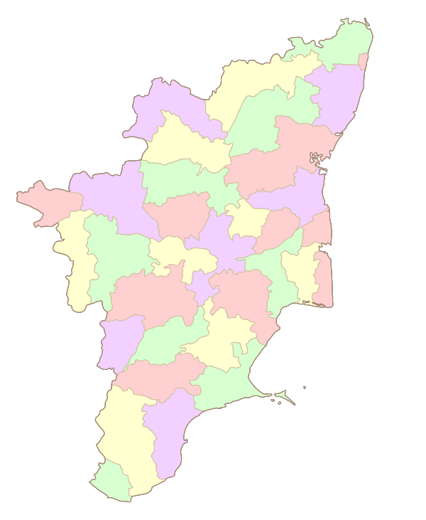
クリック可能な地図
参照
1. ↑ "Census Info 2011 Final population totals - Ariyalur district".インド政府内務省登録総局・国勢調査委員室.2013.2014年1月26日を取得した。
2. ↑ チェンナイの地区は市区であり、本部がないことを暗示している。
3. ↑ "Census Info 2011 Final population totals - Chennai district".インド政府内務省登録総局・国勢調査委員室.2013.2014年1月26日を取得した。
4. ↑ 「コインバトール地区統計ハンドブック」.Coimbatore District Administration.2015年11月21日を取得しました。
5. ↑ "Census Info 2011 Final population totals - Coimbatore district".インド政府内務省登録総局・国勢調査委員室.2013.2014年1月26日を取得した。
6. ↑「コインバトールの地区地図」。コインバトール地区行政.2009.2014年1月24日を取得しました。
7. ↑ "Census Info 2011 Final population totals - Cuddalore district".インド政府内務省登録総局・国勢調査委員室.2013.2014年1月26日を取得した。
8. ↑ "Census Info 2011 Final population totals - Dharmapuri district".インド政府内務省登録総局・国勢調査委員事務所。2013.2014年1月26日を取得した。
9. ↑ "Census Info 2011 Final population totals - Dindigul district".インド政府内務省登録総局・国勢調査委員室.2013.2014年1月26日を取得した。
10. ↑「ディンディグル地区歳入課」。エロデ地区行政。2009.2014年1月26日を取得しました。
11. ↑ 「Census Info 2011 Final population totals - Erode district」.インド政府内務省登録総局・国勢調査委員事務所。2013.2014年1月26日を取得した。
12. ↑ "Census Info 2011 Final population totals - Kancheepuram district".インド政府内務省登録総局・国勢調査委員室.2013.2014年1月26日を取得した。
13. ↑ 「国勢調査情報 2011 年最終人口合計-カンニヤクマリ地区」.インド政府内務省登録総局・国勢調査委員室.2013.2014年1月26日を取得した。
14. ↑ "Census Info 2011 Final population totals - Karur district".インド政府内務省登録総局・国勢調査委員室.2013.2014年1月26日を取得した。
15. ↑ "Census Info 2011 Final population totals - Krishnagiri district".インド政府内務省登録総局・国勢調査委員室.2013.2014年1月26日を取得した。
16. ↑ "Census Info 2011 Final population totals - Madurai district".インド政府内務省登録総局・国勢調査委員室.2013.2014年1月26日を取得した。
17. ↑ "Census Info 2011 Final population totals - Nagapattinam district".インド政府内務省登録総局・国勢調査委員室.2013.2014年1月26日を取得した。
18. ↑ "Census Info 2011 Final population totals - Namakkal district".インド政府内務省登録総局・国勢調査委員室.2013.2014年1月26日を取得した。
19. ↑ "Census Info 2011 Final population totals - Nilgiris district".インド政府内務省登録総局・国勢調査委員室.2013.2014年1月26日を取得した。
20. ↑ "Census Info 2011 Final population totals - Perambalur district".インド政府内務省登録総局・国勢調査委員室.2013.2014年1月26日を取得した。
21. ↑ "Census Info 2011 Final population totals - Pudukottai district".インド政府内務省登録総局・国勢調査委員室.2013.2014年1月26日を取得した。
22. ↑ "Census Info 2011 Final population totals - Ramanathapuram district".インド政府内務省登録総局・国勢調査委員室.2013.2014年1月26日を取得した。
23. ↑ "Census Info 2011 Final population totals - Salem district".インド政府内務省登録総局・国勢調査委員室.2013.2014年1月26日を取得した。
24. ↑ "Census Info 2011 Final population totals - Sivanganga district".インド政府内務省登録総局・国勢調査委員室.2013.2014年1月26日を取得した。
25. ↑ "Census Info 2011 Final population totals - Thanjavur district".インド政府内務省登録総局・国勢調査委員室.2013.2014年1月26日を取得した。
26. ↑ 「タンジャヴール地区の地図」.タミルナドゥ州政府.2009.2014年1月24日を取得した。
27. ↑ "Census Info 2011 Final population totals - Theni district".インド政府内務省登録総局・国勢調査委員会事務所(Office of The Registrar General and Census Commissioner, Ministry of Home Affairs, Government of India)。2013.2014年1月26日を取得した。
28. ↑ "Census Info 2011 Final population totals - Thoothukudi district".インド政府内務省登録総局・国勢調査委員室.2013.2014年1月26日を取得した。
29. ↑ "Census Info 2011 Final population totals - Tiruchirappalli district".インド政府内務省登録総局・国勢調査委員室.2013.2014年1月26日を取得した。
30. ↑ "Census Info 2011 Final population totals - Tirunelveli district".インド政府内務省登録総局・国勢調査委員室.2013.2014年1月26日を取得した。
31. ↑ "Census Info 2011 Final population totals - Tiruppur district".インド政府内務省登録総局・国勢調査委員室.2013.2014年1月26日を取得した。
32. ↑ "Census Info 2011 Final population totals - Thiruvallur district".インド政府内務省登録総局・国勢調査委員室.2013.2014年1月26日を取得した。
33. ↑ "Census Info 2011 Final population totals - Tiruvannamalai district".インド政府内務省登録総局・国勢調査委員室.2013.2014年1月26日を取得した。
34. ↑ "Census Info 2011 Final population totals - Thiruvarur district".インド政府内務省登録総局・国勢調査委員室.2013.2014年1月26日を取得した。
35. ↑ "Census Info 2011 Final population totals - Vellore district".インド政府内務省登録総局・国勢調査委員会事務所(Office of The Registrar General and Census Commissioner, Ministry of Home Affairs, Government of India)。2013.2014年1月26日を取得した。
36. ↑ "Census Info 2011 Final population totals - Viluppuram district".インド政府内務省登録総局・国勢調査委員室.2013.2014年1月26日を取得した。
37. ↑ "Census Info 2011 Final population totals - Virudhunagar district".インド政府内務省登録総局・国勢調査委員室.2013.2014年1月26日を取得した。
質問と回答
Q:テキストは何についてのものですか?
A: タミル・ナードゥ州の地区について書かれた文章です。
Q: タミル・ナードゥ州にはいくつの地区があるのですか?
A:タミル・ナードゥ州には32の地区があります。
Q:このページにはどのような情報が掲載されているのですか?
A: 各地区の人口、面積、主要都市などの情報が掲載されています。
Q: 地区の地図はありますか?
A:全32区の地図が掲載されています。
Q: 地区データ以外に提供される情報はありますか?
A: はい、地方自治体の連絡先や観光スポットなど、その他の情報も提供しています。
Q: 最新の情報ですか?
A: はい、すべてのデータは定期的に更新され、正確さを保っています。
Q: このページは誰が作成したのですか?
A: このページはタミル・ナードゥ州政府によって作成されました。
関連項目
著者
AlegsaOnline.com タミル・ナードゥ州の地区一覧:行政区画・地図と主要都市ガイド Leandro Alegsa
URL: https://ja.alegsaonline.com/art/124673